
Aerial thermal imaging is being used to record heat loss from residential properties, enabling councils to pinpoint energy “hotspots” across the country.
Leicester city council is using the system to target homeowners for free cavity and roof insulation.
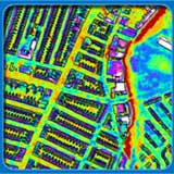
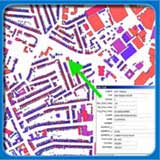
At the centre of the scheme is an aerial thermal imaging service from BlueSky. Coupled with digital mapping and geographical information systems, a thermographic map of any given area can be produced to indicate which properties are emitting the most heat.
Thermal scanning works by picking up differences in surface heat. BlueSky uses a modified military-use scanner mounted on the underside of a twin-engine aircraft to record the analogue images.
Via The Guardian.
Check also Future Currents, a Design Council website full of ideas for putting householders in control of the energy they use, produce or even sell. It also has a downloadable windmill application, which tells you how much energy you could produce with your own wind turbine and how much power it takes to produce a slice of toast. (thanks Helen)