
In 1994, ART+COM presented Terravision, an installation that enabled users to navigate in a 3D model of the earth by moving a tracking device in front of the projection showing the actual location and environment s/he is in.
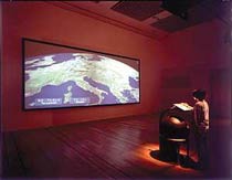
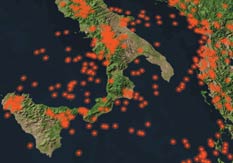
Image on the right: Visualization of danger-zones for earthquakes
The virtual globe is generated from satellite images and altitude data stored on servers located around the world, integrated into a television system by an ATM broadband network. Information can be accessed topographically and chronologically: a user can see weather patterns or zoom in on, say, the Potzdammer Platz in Berlin and use a camera icon (placed at the actual location of the original camera) to view a film of it made in 1929.
Terravision was conceived as a tool to generate knowledge about the condition and future development of our planet.
The display and the resolution were only limited by the quality of the satellite aerial images of the corresponding location.
John has just sent out via bittorrent the original video from 1995.
More images and videos on art+com website and on Media Art Net.
Other works by art+com: the Science of Aliens, timetravel telescope, Floating Numbers table.