
Augmented Maps, engineered at Cambridge University, is a system which augments an ordinary paper map with additional information by projecting it onto the map’s surface.
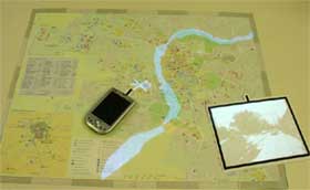
The system uses a camera and image recognition software to identify the region from the map’s topographical features. An overhead projector then overlays information – like the location of a traffic accident or the position of an helicopter – onto the map.
The system can also project photographs or video footage onto a blank surface placed next to a particular geographical feature. Other information – such as web links – can be sent to a handheld computer, through a wireless network (video).
The team have developed a simulation that projects live information about flooding in Cambridge onto a local map. Areas of flooding are superimposed onto a map of the city along with live images captured by a camera in the city’s centre.
“An operator can see the image and assess the local situation immediately,” writes Gerhard Reitmayr on the project’s homepage. “An emergency unit represented as a helicopter is visible on the map as well.”
Via New Scientist.