
 The MIT Senseable City project had a big room inside the Italian Pavilion of the Biennale this year. So i’ll just focus on that room for the moment, ‘kay? The Italian pavilion is always a glorious mess. Loads of nice surprises in there but i never know how to make sense of it.
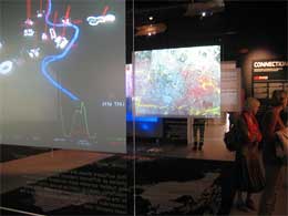
All the projects selected deal with specific aspects of the urban environment and digital technology. The star of the show was Real Time Rome, an information visualization system that combines different datasets in a single interface to reveal the rhythm of the Italian capital in real time.
Part of the room was dedicated to the work developed at the Tangible Media Group, headed by Hiroshi Ishii. Three kinds of Tangible Bits were demonstrating how artefacts can give physical form to digital information, making bits directly manipulable and perceptible.
Pinwheels are spinning in a digital wind from cyberspace (such as network traffic), showing how physical information can be communicated within an architectural space in subtle and aesthetically pleasing ways. The five sets of pinwheels in the room are connected to the Real Time Rome data and indicate the number of people visiting the Colosseo, Piazza San Pietro and other monuments of Rome. Faster movement and stronger wind indicate a higher number of people at the
monument at the current moment.
Five Ambient Orbs are connected to the Real Time Rome data and indicate the level of traffic congestion at different traffic intersections in Rome.
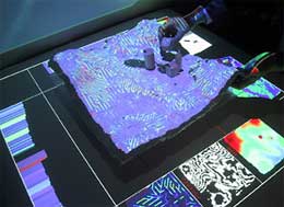
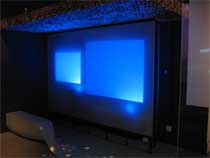
I was quite glad to finally get to see SandScape (image on the right), only that it was out of order then i visited the Biennale. This interface allows to design and understand landscapes through computational simulations using sand. These simulations are projected on the surface of a sand model that represents the terrain and you can choose from a variety of simulations that highlight either the height, slope, contours, shadows, drainage or aspect of the landscape model. You can alter the form of the landscape model by manipulating sand while seeing the resultant effects of computational analysis projected on the surface of sand.
Several information panels were detailing how the MIT BUS projects would revolutionalize the experience of taking the bus. From the bus stop to the the structure of the bus itself to its route.
With network and computational support, bus routes can become self-organizing systems in space and time much in the way of private automobiles and taxis, rather than structures with fixed routes and timetables. In the self-organizing bus system, bus operators would keep track of vehicle movements, electronically monitor demand from minute to minute, and responsively allocate service capacity to where it is needed most.
In addition, by means of mobile devices, passengers can be informed of when and where service will be available.
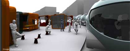
The researchers had also imagined a “reconfigurable” bus. Instead of a long, narrow box on wheels, buses could become flexible and wiggle themselves through the streets in a more agile fashion.
Buses can also become mobile network nodes (we’ve been promised that for years guys, can’t wait to get that), so that passengers are connected for guidance, entertainment and mobile work. Both interior
and exterior surfaces can carry information displays. More in MIT: RATP.
The Zaragoza Digital Mile is ubicom dream landing in Spain. Digital media would be integrated into everyday aspects of the public realm to make it more flexible and adaptable to different users, activities, or moods?

The spaces, parks and buildings on the Digital Mile include free wifi as well as open access to the digital systems and responsive media elements located along the Mile.
There’s a WATER WALL, a fountain where people can digitally control the streams of water. With a command – by jumping into the water or sending a message through an electronic device – the water can start and stop or change in pressure. Streetlight would change color or intensity in response to the time of day, demands for use, or artistic
desires. Digital street furniture -cafe tables, bus stops, and signage- display menus, bus arrivals, or the location of available parking spaces.
Affixed to the facades of buildings, URBAN PIXELS delineate the edges of the Zaragoza Digital Mile from the rest of the city. When viewed from the air or from the ground this ‘light’ footprint emphasizes
different moods or zones along the Digital Mile. Each pixel unit includes a solar charging unit and can be programmed wirelessly.
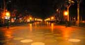 The MEMORY WALK makes visible the way people travel through the city by recording pedestrians’ steps across a space. Every time a footstep falls on a digital paver, the paver emits an additional increment of light. As people cross the pavement, paths of light are illuminated where people tread the most.
Last one, DIGITAL AWNINGS are screens that can rotate up, down, left, and right in response to people’s physical movements, or in the service of a collective special event.
There was also the prototype of an interactive bus stop. It could be used as a trip planning map, you place a finger on your destination and the bus stop will draw the shortest bus-travel path from where you are. Using GPS technology, it will also show you where the relevant buses are positioned in real time and when they will arrive at your desired destination. You can beam this itinerary to your mobile phone, or request an SMS notification when the bus is almost at your location if you don’t want to wait there.
Besides, riders and passers-by can create digital graffiti or post ads or announcements on the bus stop by drawing with their fingers on the surface or by sending an image from their mobile phones.
Each bus stop is also a wireless Internet hotspot. All bus stops in the network are connected through a wireless meshed network, thus
spreading Wireless Fidelity WiFi Internet in the city. This allows people to receive location based services through their mobile devices.
Finally, the number of bus riders at a given location determines the size of the bus shelter, varying the length of the roof, bench and touch screen, which are customized at low cost using computer aided
design and manufacturing (CAD–CAM) techniques. The roof, like a tree, changes from full opacity to transparency and adapts to weather conditions like sun and rain. It uses a Moorish pattern found in Zaragoza’s Aljaferia Palace.
The bench itself is formed by raising the ground using a CAD-CAM structure. The position and shape of the bench depend on its relation
to the sun and roof in order always to provide areas of shaded seating. Photovoltaic cells placed on the bus stop’s roof provide up to 50% of the power required for its operation in Zaragoza.
My images on flickr.