
Engineers at Berkeley have found a way to map a city very quickly, recording every window and doorway of the urban battlefield in an accurate 3D model.
The “virtualised reality” technique is similar to building a virtual reality model, but the process is automated and much faster.
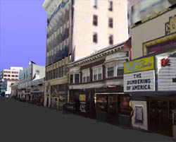
Virtualised reality scans the urban landscape using lasers and digital cameras mounted on a truck or plane. A laser measures distances to objects such as lamp posts and building facades, while the camera takes 2D photos. Another laser calculates the movement of the truck and checks its position against data collected from the aerial laser.
A computer combines these data to create the 3D model of the area. The researchers recently created a model of downtown Berkeley in just 4½ hours – 26 minutes of driving plus 4 hours of data processing.
The first user will probably be the US army, but in the future car-hire companies or cellphone providers could use it to transmit up-to-date 3D maps to their customers to help them navigate through unfamiliar cities. Emergency workers could use the models to figure out the best way to respond to disasters. Urban planners could look at a series of models collected over time to see how the layout of their city has evolved.
The Berkeley team is also working on a 4D modelling system, which would record anything from a boxing match to a ballet performance as a moving 3D model that the viewer could manipulate in virtual space.
Via New Scientist.