
Gary Look, a researcher at MIT, is looking to incorporate landmarks into automatically-generated directions using a software that models the geographical relationships between spaces and their functions.

The Location Awareness Information Representation software, dubbed Lair, can represent a person’s location, what that person is near, and what s/he can do at those nearby places, giving directions which are “similar to those a person would give”.
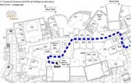
The system generates a graphical route map, then produces written directions from the map, using phrases like “turn right at the end of the hallway” or “walk through the doorway into the lounge.” Besides, “you will see” phrases assure a person is headed in the right direction.
The researchers have also developed a related tool, the Interactive Simulator for Lair Exploration, that allows users to ask questions about places and routes like “Where am I?”, “Describe this place.”, “What can I do here?”, or “Is place P along my route from X to Y?”
The query tool could be used with handheld computers that track a user’s position using indoor equivalents of GPS.
Via TRN mag.
PDF of the research.