
ANTIPODE/2 interweaves photography and cartographic process to reconstruct in virtual space the landscape of two cities (Schwabisch Hall, Germany, and Fells Point in Baltimore, Maryland) juxtaposed within one another.
The process captures the structural pattern of the cities, as well as the events occurring along the path taken by the photographer: the flow of pedestrians and traffic, commerce and cultural activity.
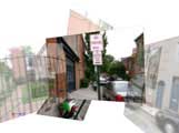
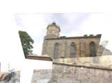
The map maker walks through the city taking pictures with a digital camera. Each exposure sends a signal to a microprocessor that reads the geographic coordinates from a GPS receiver. An electronic compass and a sensor provide local orientation and angle of the camera as the image is composed in the photo frame. The resulting images are then combined according to the coordinate date in a 3D space.
The viewer may then navigate the maps by manipulating segmented sections of traditional maps of both towns. The map segments of each town can be transposed upon one another, allowing the viewer to explore unexpected relationships between the two distant locations.
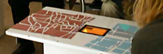
On a “coffee table and couch”, the viewer could sort through cards illustrating the map sections. The back of each card is coded with an unique pattern. As a card is placed in the center of the table, a video camera sends the pattern data to a MAX/MSP/Jitter patch which in turn sends a midi signal to the computer running the 3D map animation.
A project by faculty and students from University of Maryland and the Fachhochschule in Schwabisch Hall.
Via del.icio.us.