
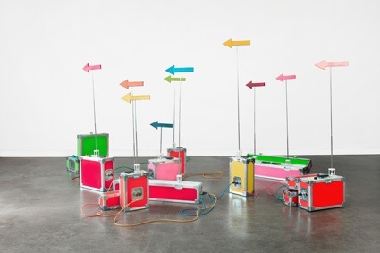
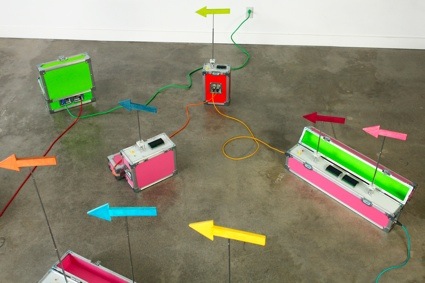
Nearest Costco, Monument or Satellite does exactly what its title suggests. Its 14 colourful arrows point you with impeccable accuracy into the direction of the nearest Costco (a warehouse club chain popular in the U.S.), monument or orbiting GPS satellite.
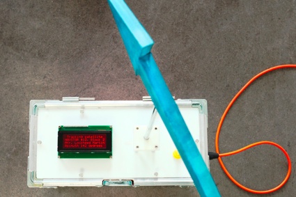
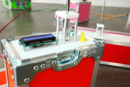
Drawing from ideas in psychogeography, locative technologies and the human sense of location, the work consists of networked electronic pointing devices built into individual flight cases. Each case contains the electronics required to control a pointer arrow held above the case by a telescoping antenna. At its literal base, the cases contain and represent the rational, networked, technologized information available on place and direction. From this base, the antennas extend this information up into a swaying field of poetic movements, governed by materiality more than information.
The absurd piece turns the human sense of direction into a mechanical performance and critically comments on the way our daily perception of the environment is mediated by technology. Nearest Costco, Monument or Satellite will be part of the upcoming edition of the Sight & Sound, a festival that brings together digital artworks under a common theme. This year the festival explores the idea of being ‘hyperlocal’ and Daniel Jolliffe‘s piece responds well to S+S’s exploration of the horizontality of networked art production and its contextualization within an ultra-localized setting.
Since i suspected that Nearest Costco, Monument or Satellite was more than the sum of its very humourous parts, i contacted Daniel Jolliffe to know more about his work:
Hi Daniel! One of the striking characteristics of the work is how cheerful and colorful it is. What made you decide to make the installation so visually appealing?
For a long time I have been making works that use sculpture as a kind of camouflage for the electronic systems that give rise to a piece. Partly, this is because I think the idea that plain, or exposed electronics in a work puts ideas about technology in the viewer’s head that come mostly from movie clichés about futurist robots and the like. Most people, when presented with an electronic system that is all diodes and motors and integrated circuits have a hard time knowing what is really going on. This means in turn that the possibility of being critical about the ideas in the work gets eaten up by the complex cliché of the technical system. As an artist I would prefer to avoid the discussion of how something works on a technical level, and encourage instead the discussion of what issues the work explores. So, I almost always put the electronic systems I use into sculptural forms that act as a kind of camouflage for the technical system of the work. For “Nearest Costco, Monument or Satellite” (NCMS) I went to a lot of trouble to find certain colours for the sculptures and the cables in order to generate the visual feeling you are talking about– the zone of technological encounter that is playful, non-threatening and hopefully beautiful. I think it also never hurts to employ some classic visual art strategies like colour to engage the viewer on a purely visual level to start off.
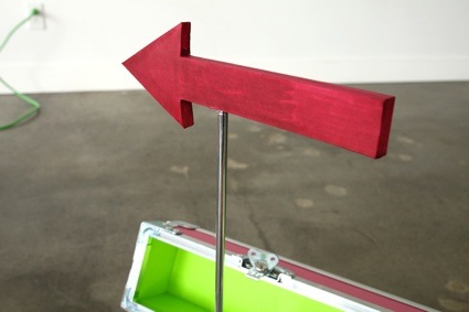
 (Nearest) Costco, monument or orbiting GPS satellite(s). Why did you pick up the location of those three? Why not nail salons or art museum, for example?
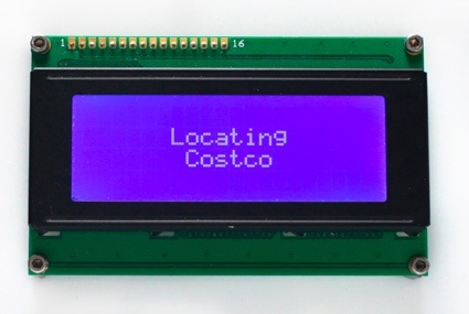
The answer to this threads into your first question, as the colour has a lot to do with humour. Lately I have been very interested in having some humour in my work. My performance/sculpture/web work One Free Minute had moments of humour, and I realized with that piece with how powerful it is to make make the viewer laugh. You can make them laugh, and then make them think. In NCMS, the whole premise of the piece is humorous: it’s a kind of ridiculous system that actually works! It points to the nearest Costco (from the current show in Wroclaw, it is pointing to the nearest Costco in the UK), the nearest well-known monument (the Aleksander Fredro Statue in Wroclaw) and it goes into a third mode to track the orbiting GPS Satellites. You can, of course, find all these things in a few minutes on your cell phone. Even the current positions of GPS satellites are easily found online.
On a more serious level, the three things NCMS points to are loose placeholders for the way we conceptualize places and location in the contemporary mind. Most people can conceptualize in their mind the route from their house to the nearest Costco, IKEA or major chain store. This is one way of thinking about location in the contemporary mind. Another is when you are talking to a friend on the phone or texting to arrange a meeting place: we could meet here, in front of this statue or there, in front of that yellow building. This is a kind of call to the collective memory of place.
The third function– pointing to GPS satellites– tries to talk about how irrelevant that information is, and in turn about how abstracted and distanced we are from the machines that generate ideas of location in our minds.
So the piece is kind of elaborate joke, but it’s a serious one. I say this because I think that within the quick and efficient access to location data that we have on our cell phones, there is something lost in the human experience. This is really what this piece is about. It slows down the process of locating things, putting it into a ridiculous visual component form that hopefully makes you think about the the faster systems that we all actually use to find things in real life.
 I had a look at the video of the work of course and believe it or not, i was actually amazed to see that all the arrows ended up pointing to the exact same direction. does it always work so flawlessly? Apologies for the dumb question but what happens when the nearest monument is actually 2 monuments located at the same distance from your piece?
I’ve just set it up at the WRO media art Biennale in Wroclaw, and watching it, I’m amazed too that it does indeed flawlessly point out the actual locations. The way it is programmed, it sometimes takes one or two of the arrow pointers a while to catch up. It’s like the person in a group of people who finally agrees with the others about the right way to get to the restaurant. This makes me laugh almost every time.
There is no confusion about pointing to the nearest monument, and it does this spot-on every time. The way I get this information very low-tech. First I ask a number of local people where the most significant and well- known local monuments and meeting places are. Once i decide which one the piece will point to, I ask two or three local people to do that in real life. After that I turn the way they pointed with their arms (the angle, basically) into code for the piece. This way the arrows are just reproducing what a local person would do if you asked them.
 Was there any challenge you encountered while developing the work?
About a hundred, but happily they are all behind me now! It took a long time to figure out how to get the arrows into the air and have them reliably point. I also did three different sculptural prototypes of the work before I came up with this one.
What’s next for you? Any upcoming event, field of research or project you’d like to share with us?
I am working on some more work to do with humour. This piece is travelling a few places this year, to Montreal, then to the Museum of Nantes in France and finally to ISEA in Vancouver.
Thanks Daniel!
Check out Daniel Jolliffe’s Nearest Costco, Monument or Satellite at the Sight & Sound festival in Montreal next week from 20 May until 24 May 2015. The programme is pretty good this year, Nicolas Maigret will launch another of his drone performances and Martin Howse will be doing a Earth Coding workshop.