
MIT SENSEable City Lab (famous for Mobile Landscape Graz) is working on the Real Time Rome project for the 2006 Venice Biennale of architecture.
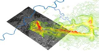
The project combines different datasets in a single interface to reveal the rhythm of the city in real time. RTR aggregates mobility of people according to their mobile phone usage and visualizes it synchronously with the flux of public transit, pedestrians, and traffic to better understand patterns of daily life in Rome and show how technology can help individuals make more informed decisions about their environment.
The data of the movements of a mobile phone location will be anonymously visualized on a map. The algorithms used are able to spot the difference between a slow mobile phone in the pocket of a pedestrian or the phone of a driver stuck in one of Rome’s monstruous traffic jams.
Using this instrument, one would be able to choose the fastest street to get to lunch but also the quietest restaurant. An analysis of country codes gives detailed information about the flow of tourists: where are Germans going? how do Japanese move in the city? Combining traffic and public transport data will help understand if the number of buses available matches the density and requirements of usage. Users would be able to check on their phone screen the nearest taxi or parking space.
Rome was chosen as test bed for the project because “in 1748, Nolli’s map of Rome introduced modern cartography,” explains Carlo Ratti, Director of senseable. “The maps of the future will be huge database that will enable us to extract fragments that suit our needs, like we can do today on Internet”.
Maps of Rome.
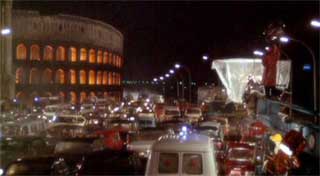
Via PPF and la repubblica. Second image from Roma, the 1972 movie by Fellini.